


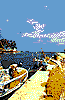
AGIA MARINA
 Agia Marina is located at a distance
of 9 km. west of Hania. This is a busy tourist
resort with about 800 residents. Here, you
will visit the small church of Agia
Marina,giving its name to the village, which
has also been connected with great moments
of cretan opposition against the german
occupation.
Starting out from Agia Marina you can visit
the small isle of Agioi Theodori, where you
will have a chance to see the unique wild
cretan goats, as well as the Nerospilia
(Watercave) with the beautiful stalactites and
stalagmites.
Agia Marina is located at a distance
of 9 km. west of Hania. This is a busy tourist
resort with about 800 residents. Here, you
will visit the small church of Agia
Marina,giving its name to the village, which
has also been connected with great moments
of cretan opposition against the german
occupation.
Starting out from Agia Marina you can visit
the small isle of Agioi Theodori, where you
will have a chance to see the unique wild
cretan goats, as well as the Nerospilia
(Watercave) with the beautiful stalactites and
stalagmites.
 Agia Roumeli is located 60 km.
south of Hania. This is a small, sunwashed
resort with very few residents, built next to
an exquisite beach with crystal clear waters.
Its modern name comes from the chrurch of
Agia Roumeli, which is built on the older,
roman temple of Agia Roumilia or Roumina.
At the site of the contemporary village it is
believed that was the ancient city Taras, the
ruinw of which have been dated to the 5th
century B.C. As proven by the excavations,
the city of Taras was of great economic
importance for the area, cutting its own coins,
and as it is proven by the temple of Tarsios
Apollo or Artemis, which was located at the
exit of the gorge, this was also an importan
religious center during antiquity. Today, at
the site of the ancient temple, you will spot
the church of Panagia (the Holy Mother),
exhibiting worthwhile mosaics of the 15th
century.
During the summer months, lots of visitors
come to Agia Roumeli, since the village is
located at a distance of 1.5 km. from the exit
of the Gorge of Samaria. From Agia Roumeli
and at a walking distance of about an hour
you will find the small byzantine church
where it is said that the Apostle Paul came to
teach.
Agia Roumeli is located 60 km.
south of Hania. This is a small, sunwashed
resort with very few residents, built next to
an exquisite beach with crystal clear waters.
Its modern name comes from the chrurch of
Agia Roumeli, which is built on the older,
roman temple of Agia Roumilia or Roumina.
At the site of the contemporary village it is
believed that was the ancient city Taras, the
ruinw of which have been dated to the 5th
century B.C. As proven by the excavations,
the city of Taras was of great economic
importance for the area, cutting its own coins,
and as it is proven by the temple of Tarsios
Apollo or Artemis, which was located at the
exit of the gorge, this was also an importan
religious center during antiquity. Today, at
the site of the ancient temple, you will spot
the church of Panagia (the Holy Mother),
exhibiting worthwhile mosaics of the 15th
century.
During the summer months, lots of visitors
come to Agia Roumeli, since the village is
located at a distance of 1.5 km. from the exit
of the Gorge of Samaria. From Agia Roumeli
and at a walking distance of about an hour
you will find the small byzantine church
where it is said that the Apostle Paul came to
teach.
 The village of Askifou, at an altitude
of 730 meters, is located about 50 km.
southeast of Hania. Its name originates from
the ancient greek word "skifos", meaning
"cup" and it apparently has to do with the
shape of the mountain plateau surrounding
it.
During the Cretan Insurrection against the
Turks, the villagers took part in the heroic
battle which led to the destruction of the
forces of Sherif Pasha, in the straights of
Lagos in August 1821. This was also the
village chosen by the the General Cretan
Foundation in 1896, to meet in order to
officiate the islands union with the rest of
Greece.
The inhabitants of Skifou live off the
intensive cultivation of the rich lands of the
plateau, producing potatoes, cereals,
chestnuts and wine. Many visitors, whoc wish
to enjoy the unique view and the famous
cheese pies of Skyfou, choose to make a stop
at its traditional tavernas and coffee shops.
The village of Askifou, at an altitude
of 730 meters, is located about 50 km.
southeast of Hania. Its name originates from
the ancient greek word "skifos", meaning
"cup" and it apparently has to do with the
shape of the mountain plateau surrounding
it.
During the Cretan Insurrection against the
Turks, the villagers took part in the heroic
battle which led to the destruction of the
forces of Sherif Pasha, in the straights of
Lagos in August 1821. This was also the
village chosen by the the General Cretan
Foundation in 1896, to meet in order to
officiate the islands union with the rest of
Greece.
The inhabitants of Skifou live off the
intensive cultivation of the rich lands of the
plateau, producing potatoes, cereals,
chestnuts and wine. Many visitors, whoc wish
to enjoy the unique view and the famous
cheese pies of Skyfou, choose to make a stop
at its traditional tavernas and coffee shops.
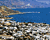
 The seaside village of Georgioupolis
is located 38 km. southeast of Hania and it
has about 500 inhabitants. Although we have
no formal proof from archaeological
excavations, it is believed that this was the
location of ancient Amfimalla, one of the
ports of the city of Lappa. The village is
named after one of the island Governors,
Prince George.
Today, Georgioupolis is considered on of
most important tourist resorts of Crete, as its
exquisite beaches attract great numbers of
visitors every summer.
From Georgioupolis you will have the chance
to visit the Kourna Lake, the only lake on the
island, and the nearby village which shares its
name. The Kourna Caves were discovered in
1961 at the south side of the lake, presenting
a unique site.
The seaside village of Georgioupolis
is located 38 km. southeast of Hania and it
has about 500 inhabitants. Although we have
no formal proof from archaeological
excavations, it is believed that this was the
location of ancient Amfimalla, one of the
ports of the city of Lappa. The village is
named after one of the island Governors,
Prince George.
Today, Georgioupolis is considered on of
most important tourist resorts of Crete, as its
exquisite beaches attract great numbers of
visitors every summer.
From Georgioupolis you will have the chance
to visit the Kourna Lake, the only lake on the
island, and the nearby village which shares its
name. The Kourna Caves were discovered in
1961 at the south side of the lake, presenting
a unique site.
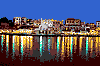 Hania is the capital city of the
Municipality of Hania, with 60.000
inhabitants. They are built at the site of the
aqncient town of Kydonia, one of the oldest
inhabited areas on the island. Its modern
times name was given by the Arabs. In 1252,
under the Venetian occupation, the town
begun its fortification projects, which were
finished in 1590. Hania was the first town in
Crete occupied by the Turks, in 1654, until it
was freed in 1898, when it also became the
capital of the by then autonomous island.
Today in Hania, the visitor will distinguish
the modern from the traditional parts of the
town, which includes areas such as the Top
Hana or Topana, the Jewish neighbourhood,
the Santrivani, the Spalntzia or Plaza, and the
Casteli. Among the buildings surrounding the
busy little port you will note the older
structures of the venetian and the turkish
occupation periods, as well as the newer
buildings with modern architecture. The
town monuments, its squares and its streets
testify to its glorious history. Here you will
also find many memorials to Eleftherios
Venizelos, the great, forward looking
politician who was born in the village of
Mournies and spent a great part of his life in
Hania.
In the town, it is wothwile to visit the Halepa
neighbourhood with the breathtaking
mansions as well as the church of Saint Maria
Magdalene, the arcaeological excavation sites
of ancient Kidonia in Casteli (nearby the port)
the metropolitan Cathedral, the Municipal
and Zoologigal Gardens and the Municipal
Market. Here, you will also find the
Archaeological, Laographic, Historical and
Nautical Museum as well as the Municipal
Library.
Hania is the capital city of the
Municipality of Hania, with 60.000
inhabitants. They are built at the site of the
aqncient town of Kydonia, one of the oldest
inhabited areas on the island. Its modern
times name was given by the Arabs. In 1252,
under the Venetian occupation, the town
begun its fortification projects, which were
finished in 1590. Hania was the first town in
Crete occupied by the Turks, in 1654, until it
was freed in 1898, when it also became the
capital of the by then autonomous island.
Today in Hania, the visitor will distinguish
the modern from the traditional parts of the
town, which includes areas such as the Top
Hana or Topana, the Jewish neighbourhood,
the Santrivani, the Spalntzia or Plaza, and the
Casteli. Among the buildings surrounding the
busy little port you will note the older
structures of the venetian and the turkish
occupation periods, as well as the newer
buildings with modern architecture. The
town monuments, its squares and its streets
testify to its glorious history. Here you will
also find many memorials to Eleftherios
Venizelos, the great, forward looking
politician who was born in the village of
Mournies and spent a great part of his life in
Hania.
In the town, it is wothwile to visit the Halepa
neighbourhood with the breathtaking
mansions as well as the church of Saint Maria
Magdalene, the arcaeological excavation sites
of ancient Kidonia in Casteli (nearby the port)
the metropolitan Cathedral, the Municipal
and Zoologigal Gardens and the Municipal
Market. Here, you will also find the
Archaeological, Laographic, Historical and
Nautical Museum as well as the Municipal
Library.
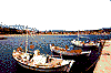
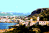
 Hora Sfakion, with 350 ihabitants, is
located at a distance of 74 km. south of
Hania and is built at the center of a hidden
cove in an area noted for the wilderness and
the remoteness, which - as it is said - reflects
in the personality and character of its
inhabitants. Those courageous and free
spirited people turned to the sea in order to
make a living and for many years they chose
to be sailors and commercial traders.
Sfakia have always been connected with the
great moments of cretan history. During the
Venetian occupation the village had great
financial development and the number of its
inhabitants rose to 3000. At that time its
fortress, Castelli, was built, becoming also the
home of the local Venetian governor.
Although the failed insurrection of 1770 was
"drained in blood" the townspeople never
gave up and kept fighting the Turks at every
opportunity given.
On May 31st, 1941, the little port of Sfakia
was used - with the help of the villagers - by
New Zealanders and Australians who had
remained behind the main allied forces, in
order to escape.
Today, among the houses in the village, you
will find many 300 to 400 year old mansios,
testifying to its glorious history.
Starting out from Sfakia it is worthwhile to
pay a visit to the Church of Panagia of
Thymiani, to the village of Komitades as well
as to the legendary Fragocastello.
Hora Sfakion, with 350 ihabitants, is
located at a distance of 74 km. south of
Hania and is built at the center of a hidden
cove in an area noted for the wilderness and
the remoteness, which - as it is said - reflects
in the personality and character of its
inhabitants. Those courageous and free
spirited people turned to the sea in order to
make a living and for many years they chose
to be sailors and commercial traders.
Sfakia have always been connected with the
great moments of cretan history. During the
Venetian occupation the village had great
financial development and the number of its
inhabitants rose to 3000. At that time its
fortress, Castelli, was built, becoming also the
home of the local Venetian governor.
Although the failed insurrection of 1770 was
"drained in blood" the townspeople never
gave up and kept fighting the Turks at every
opportunity given.
On May 31st, 1941, the little port of Sfakia
was used - with the help of the villagers - by
New Zealanders and Australians who had
remained behind the main allied forces, in
order to escape.
Today, among the houses in the village, you
will find many 300 to 400 year old mansios,
testifying to its glorious history.
Starting out from Sfakia it is worthwhile to
pay a visit to the Church of Panagia of
Thymiani, to the village of Komitades as well
as to the legendary Fragocastello.
 The seaside village of Kalives is
located at a distance of about 18 km. east of
Hania. This is a small resort of about 1.100
inhabitants, built in a beautiful, green area.
The village of Kalives is divided into two
communities, the modern one with
contemporary architectural structures and
the traditional, with stone houses and narrow
lanes.
The seaside village of Kalives is
located at a distance of about 18 km. east of
Hania. This is a small resort of about 1.100
inhabitants, built in a beautiful, green area.
The village of Kalives is divided into two
communities, the modern one with
contemporary architectural structures and
the traditional, with stone houses and narrow
lanes.
 The beautiful town of Kastelli
Kissamou is the capital of Kissamos county,
located 36 km west of Hania. Here stood the
ancient city of Kissamos, an independent city,
and the harbour of Polyrrinia. During the
Venetian Rule, a castle was built here (castle
= Kastelli), the ruins of which, one can still
visit.
The modern town of Kastelli, built in
a fertile valley with olive-trees and vineyards,
is a significant commercial and tourist centre.
It is the port that connects Crete with the
Peloponnese (Gythio, Kalamata and
Neapolis), as well as with the island of
Kithira.
When in the area, one should visit the
archaeological collection housed in a room of
the former venetian-Turkish head-quarters,
as well as the ruins of the roman aqueduct
and buildings at Kria Brysi.
The beautiful town of Kastelli
Kissamou is the capital of Kissamos county,
located 36 km west of Hania. Here stood the
ancient city of Kissamos, an independent city,
and the harbour of Polyrrinia. During the
Venetian Rule, a castle was built here (castle
= Kastelli), the ruins of which, one can still
visit.
The modern town of Kastelli, built in
a fertile valley with olive-trees and vineyards,
is a significant commercial and tourist centre.
It is the port that connects Crete with the
Peloponnese (Gythio, Kalamata and
Neapolis), as well as with the island of
Kithira.
When in the area, one should visit the
archaeological collection housed in a room of
the former venetian-Turkish head-quarters,
as well as the ruins of the roman aqueduct
and buildings at Kria Brysi.
 The islet of Gavdos, opposite Sfakia, is
the southern-most border of Greece and
Europe. It is 24 nautical miles away from Agia
Roumeli, right in the middle of the Libyan
Sea.
According to Callimachus, this is the
ancient isle of Ogygia where, as Homer claims
in "Odyssey", the nymph Calypso lived. Other
names of Gavdos in the past were "Cavdos"
and "Clavdos" (Ptolemens and Ierocles),
"Glavdi" (the Epistles), "Gozzo" (the
Venetians) and "Bougadoz" (the Turks).
In the first Byzantine period, Gavdos
had a bishop, as it had many inhabitants, but,
during the Venetian Rule, the islet was
abandoned, as pirates sought refuge there.
Until the late 18th, early 19th century,
Gavdos belonged to Sfakia and was part of
the Municipality of Anopolis Sfakion. In 1925,
it was pronounced a separate community, and
remained part of the county of Sfakia, until
1950. Then, since the majority of the locals
had moved to Paleohora, Gavdos became
part of the county of Selinos.
Bibliography mentions the existence
of 172 inhabitants in the settlements of Kastri,
Ambelos, Vabiana and Metochia, as well as
the existence of pre-war settlements such as
Drethiana, Xenaki, Galana, Fragliathana.
Today, apart from the harbour Karave, there
are three village on the islet: Kastri (the
capital), Vatsiana and Ambelos. The year-
round inhabitants number approximately 40.
Gavdos is shaped triangularly, its
terrain plain and semi-rocky and the climate
warm and dry, with few rain showers. A big
part of the island is covered with pine-trees
and cedars, the products of which are known
for their aphrodisiac qualities. The islet's
beaches (Saracenico, Korfos, Tripiti, Ag.
Ioannis, Potamos), having recently won the
award "Golden Starfish", lie here proud,
golden, with crystal waters.
The islet of Gavdos, opposite Sfakia, is
the southern-most border of Greece and
Europe. It is 24 nautical miles away from Agia
Roumeli, right in the middle of the Libyan
Sea.
According to Callimachus, this is the
ancient isle of Ogygia where, as Homer claims
in "Odyssey", the nymph Calypso lived. Other
names of Gavdos in the past were "Cavdos"
and "Clavdos" (Ptolemens and Ierocles),
"Glavdi" (the Epistles), "Gozzo" (the
Venetians) and "Bougadoz" (the Turks).
In the first Byzantine period, Gavdos
had a bishop, as it had many inhabitants, but,
during the Venetian Rule, the islet was
abandoned, as pirates sought refuge there.
Until the late 18th, early 19th century,
Gavdos belonged to Sfakia and was part of
the Municipality of Anopolis Sfakion. In 1925,
it was pronounced a separate community, and
remained part of the county of Sfakia, until
1950. Then, since the majority of the locals
had moved to Paleohora, Gavdos became
part of the county of Selinos.
Bibliography mentions the existence
of 172 inhabitants in the settlements of Kastri,
Ambelos, Vabiana and Metochia, as well as
the existence of pre-war settlements such as
Drethiana, Xenaki, Galana, Fragliathana.
Today, apart from the harbour Karave, there
are three village on the islet: Kastri (the
capital), Vatsiana and Ambelos. The year-
round inhabitants number approximately 40.
Gavdos is shaped triangularly, its
terrain plain and semi-rocky and the climate
warm and dry, with few rain showers. A big
part of the island is covered with pine-trees
and cedars, the products of which are known
for their aphrodisiac qualities. The islet's
beaches (Saracenico, Korfos, Tripiti, Ag.
Ioannis, Potamos), having recently won the
award "Golden Starfish", lie here proud,
golden, with crystal waters.
 The village of Kolimbari is located 23
km. west of Hania, and is built in an area of
great natural beuaty. The village has played
an important role in cretan history. This was
the site of the turkish invation in 1645 as well
as the place where in February 1897,
Timoleon Vassos, begun the Cretan Struggle
for the unification of the island with th rest of
independent Greece.
Today, the about 750 residents of the village
live off the poroduction of the famous
Kisamos wines as well as off tourism which
has great development during the last few
years.
From Kolimbari, you will have the opportunity
to visit the ruins of the ancient town of
Diktina, at the end of Cpae Rodopou, as well
as the Gonias Monastery, dedicated to the
Virgin Mary, and was built in 1618.
The village of Kolimbari is located 23
km. west of Hania, and is built in an area of
great natural beuaty. The village has played
an important role in cretan history. This was
the site of the turkish invation in 1645 as well
as the place where in February 1897,
Timoleon Vassos, begun the Cretan Struggle
for the unification of the island with th rest of
independent Greece.
Today, the about 750 residents of the village
live off the poroduction of the famous
Kisamos wines as well as off tourism which
has great development during the last few
years.
From Kolimbari, you will have the opportunity
to visit the ruins of the ancient town of
Diktina, at the end of Cpae Rodopou, as well
as the Gonias Monastery, dedicated to the
Virgin Mary, and was built in 1618.
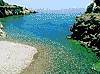
 The seaside village of Loutro is
located at a distance of about 85 km. south of
Hania, at the end of Cape Mouri. It is
believed that this was the site of the ancient
city of Finikas, which is reffered to in the
"Apostles' Acts" and was the port of ancient
Anopolis. Later, it became the winter time
port of the town of Sfakia, due to the fact that
the enclosed bay and the small island in its
entrance create a natural harbour where ships
can be safe even at very bad weather
conditions.
The village was named after the baths which
have been found in the area and from which
water was directed to nearby Anopolis.
Today, the village is a great attraction for
tourists who come here in great numbers
during the summer. Among the older
buildings that you can see here, you will find
the Municipal Building used by the first
government, in 1821.
From Loutro you can visit the ruins of the
ancient town of Aradena, with the Byzantine
Curch of Archangel Michael as well as the
ruins of ancient Anopolis.
The seaside village of Loutro is
located at a distance of about 85 km. south of
Hania, at the end of Cape Mouri. It is
believed that this was the site of the ancient
city of Finikas, which is reffered to in the
"Apostles' Acts" and was the port of ancient
Anopolis. Later, it became the winter time
port of the town of Sfakia, due to the fact that
the enclosed bay and the small island in its
entrance create a natural harbour where ships
can be safe even at very bad weather
conditions.
The village was named after the baths which
have been found in the area and from which
water was directed to nearby Anopolis.
Today, the village is a great attraction for
tourists who come here in great numbers
during the summer. Among the older
buildings that you can see here, you will find
the Municipal Building used by the first
government, in 1821.
From Loutro you can visit the ruins of the
ancient town of Aradena, with the Byzantine
Curch of Archangel Michael as well as the
ruins of ancient Anopolis.
 The village of Maleme, with about
550 inhabitants, is located at a distance of 17
km. west of Hania. Before the Second World
War this was the site of the Hania aorport,
where in 1941 the villagers took part in the
"Battle of Crete" trying to keep parachutists
from invading the island. Today, Maleme is
very much developed as a tourist resort,
attracting great numbers of visitors during
the summer months.
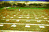
From Maleme you have easy access to the
Kafkales site, where you will see the ruins of
a hatched grave dating from the later minoan
period, as well as the German Cemetary.
The village of Maleme, with about
550 inhabitants, is located at a distance of 17
km. west of Hania. Before the Second World
War this was the site of the Hania aorport,
where in 1941 the villagers took part in the
"Battle of Crete" trying to keep parachutists
from invading the island. Today, Maleme is
very much developed as a tourist resort,
attracting great numbers of visitors during
the summer months.
From Maleme you have easy access to the
Kafkales site, where you will see the ruins of
a hatched grave dating from the later minoan
period, as well as the German Cemetary.
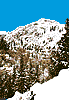
 The mountain village of Omalos is
located at a distance of 39 km. south of
Hania, and is built on the homonemous
plateau, at an altitude of 1,050 meters. Due
to the terrain, with the high, remote
mountains, Cretan revolutionaries chose the
area during the turkish occupation, in order
to find shelter. Today, the few residents of
the village live off animal husbandry and the
cultivation of potatoes and cereals, which
however is not extensive.
From Omalos, you may visit the hill of Agios
Panteleimonas as well as the grave of the
heroic fighter Hatzimihalis Giannaris, who
fought with all his might during the
independence wars of the Cretans, in 1866,
1878, 1897 and 1912.
The mountain village of Omalos is
located at a distance of 39 km. south of
Hania, and is built on the homonemous
plateau, at an altitude of 1,050 meters. Due
to the terrain, with the high, remote
mountains, Cretan revolutionaries chose the
area during the turkish occupation, in order
to find shelter. Today, the few residents of
the village live off animal husbandry and the
cultivation of potatoes and cereals, which
however is not extensive.
From Omalos, you may visit the hill of Agios
Panteleimonas as well as the grave of the
heroic fighter Hatzimihalis Giannaris, who
fought with all his might during the
independence wars of the Cretans, in 1866,
1878, 1897 and 1912.
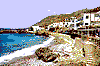
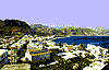 The seaside village of Paleohora is
located at a distance of 74.5 km. southwest of
Hania. With 2000 residents, this - after
Ierapetra - is the biggest town in southern
Crete. According to historians, this is the
location of the ancient city of Kalamidi.
During the last few years, Paleohora has
turned into one of the busiest tourist
destinations on the island, attracting great
numbers of visitors during the summer
months. In the town you will find the
Museum of History, worth visiting due to its
many exhibits testifying to the glorious
history of the area.
Next to the resort, you will find the fortress
Castel Selino, built by the Duke of Crete,
Marino Gradonico in 1279-82, in order to
protect the harbour from invations from the
sea and the Duke's property and riches from
the uprisings of the locals. The fortress was
later destroyed by the revolutionaries, in
order to be refortified in 1334. As we see it
today, it is the result of further conctrsuction
after its destruction by the Pirate,
Barnbarossa, in 1539.
Starting out from Paleohora, you will have the
chance to visit the caves of Zoures and haraks
in the village of Azogires, which, it is believed
was chosen by the 99 Fathers of our Church
in order to lead their monastic lives. You will
also have a chance to visit the small offshore
isle of Gavdos.
The seaside village of Paleohora is
located at a distance of 74.5 km. southwest of
Hania. With 2000 residents, this - after
Ierapetra - is the biggest town in southern
Crete. According to historians, this is the
location of the ancient city of Kalamidi.
During the last few years, Paleohora has
turned into one of the busiest tourist
destinations on the island, attracting great
numbers of visitors during the summer
months. In the town you will find the
Museum of History, worth visiting due to its
many exhibits testifying to the glorious
history of the area.
Next to the resort, you will find the fortress
Castel Selino, built by the Duke of Crete,
Marino Gradonico in 1279-82, in order to
protect the harbour from invations from the
sea and the Duke's property and riches from
the uprisings of the locals. The fortress was
later destroyed by the revolutionaries, in
order to be refortified in 1334. As we see it
today, it is the result of further conctrsuction
after its destruction by the Pirate,
Barnbarossa, in 1539.
Starting out from Paleohora, you will have the
chance to visit the caves of Zoures and haraks
in the village of Azogires, which, it is believed
was chosen by the 99 Fathers of our Church
in order to lead their monastic lives. You will
also have a chance to visit the small offshore
isle of Gavdos.
 The picturesque fishing village of
Sougia is located in 67 km from Hania. It is
built on the grounds of the ancient town of
Suia. Modern Sougia attracts many tourists,
mainly because of its remarkable, thin-
pebbled beach and the surrounding green
slopes with the pine-trees. The 150
inhabitants are occupied with tourism and
fishing, as within a small distance, in the
west, there is a well-protected natural cove.
One should visit the ruins of the
Roman Period and the basilica which was
excavated by A. Orlando. At a small distance
lies the ancient city of Lissos, where the
famous Asclipieum stood, upon the ruins of
which the church of Agios Kiricus was built.
The picturesque fishing village of
Sougia is located in 67 km from Hania. It is
built on the grounds of the ancient town of
Suia. Modern Sougia attracts many tourists,
mainly because of its remarkable, thin-
pebbled beach and the surrounding green
slopes with the pine-trees. The 150
inhabitants are occupied with tourism and
fishing, as within a small distance, in the
west, there is a well-protected natural cove.
One should visit the ruins of the
Roman Period and the basilica which was
excavated by A. Orlando. At a small distance
lies the ancient city of Lissos, where the
famous Asclipieum stood, upon the ruins of
which the church of Agios Kiricus was built.
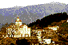
 The historic village of Theriso is
located 16 km south of Hania, before the
slopes of Lefka Ori. The road to the village
crosses the imposing gorge of Eleftherios
Venizelos, which is 6 km long.
Theriso is known for its role in the
modern history of Greece, as here, in 1905,
Eleftherios Venizelos declared the revolution
against the monarchy of Prince George who
was forced upon the Greek people by the
Great Powers. This revolution resulted in the
union of Crete with the rest of Greece.
The head-quarters of Venizelos, in the
village is a site worth visiting. It would also
be nice to visit the Saracena cave, 2 km
outside the village, where ancient pots were
found.
The historic village of Theriso is
located 16 km south of Hania, before the
slopes of Lefka Ori. The road to the village
crosses the imposing gorge of Eleftherios
Venizelos, which is 6 km long.
Theriso is known for its role in the
modern history of Greece, as here, in 1905,
Eleftherios Venizelos declared the revolution
against the monarchy of Prince George who
was forced upon the Greek people by the
Great Powers. This revolution resulted in the
union of Crete with the rest of Greece.
The head-quarters of Venizelos, in the
village is a site worth visiting. It would also
be nice to visit the Saracena cave, 2 km
outside the village, where ancient pots were
found.
 The picturesque village of Vrysses is
situated 31 km south-east of Hania, on the
way to Hora Sfakion.
It is a green, fertile area crossed by
the Brysiotiko. The village's dairy products
are famous, and travellers from all over enjoy
them in the shady village squares.
The nearby cave of Kera Spiliotissa, of
great archaeological interest, is also worth a
visit.
The picturesque village of Vrysses is
situated 31 km south-east of Hania, on the
way to Hora Sfakion.
It is a green, fertile area crossed by
the Brysiotiko. The village's dairy products
are famous, and travellers from all over enjoy
them in the shady village squares.
The nearby cave of Kera Spiliotissa, of
great archaeological interest, is also worth a
visit.


http://www.areianet.gr/infoxenios/
