


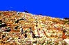
 The archaeological site of Gournia is
located 19 km south-east of Agios Nikolaos.
This area was covered by an ancient city
which thrived during the Late Minoan Period
(1600 - 1400 BC). According to the most
‘popular’ version, the area was called
"Gournia" because of the ancient cisterns
("gournes" in Greek), located next to each
house, used to feed the livestock. The decline
of the city began in 1200 BC or, according to
others, in 1450 BC when a large-scale fire
destroyed the town.
The most prominent of the finds,
from the excavations conducted by American
H. Boyd in the beginning of the century
(1901-4), are the palace, the residence of the
local administrator, the market and the
grounds of the stone houses with the slate-
paved alleys. The finds also include a number
of ceremonial items, utensils and household
tools, hinting at the area's history and daily
life which is believed to have included stock-
breeding, carpentry and fishing.
The archaeological site of Gournia is
located 19 km south-east of Agios Nikolaos.
This area was covered by an ancient city
which thrived during the Late Minoan Period
(1600 - 1400 BC). According to the most
‘popular’ version, the area was called
"Gournia" because of the ancient cisterns
("gournes" in Greek), located next to each
house, used to feed the livestock. The decline
of the city began in 1200 BC or, according to
others, in 1450 BC when a large-scale fire
destroyed the town.
The most prominent of the finds,
from the excavations conducted by American
H. Boyd in the beginning of the century
(1901-4), are the palace, the residence of the
local administrator, the market and the
grounds of the stone houses with the slate-
paved alleys. The finds also include a number
of ceremonial items, utensils and household
tools, hinting at the area's history and daily
life which is believed to have included stock-
breeding, carpentry and fishing.
 The archaeological site of Kato Zakros
is located 108 km south-east of Agios
Nikolaos. In 1901, the English archaeologist,
D. Hogarth, began excavations in the area. The
work continued in 1961 by professor N.
Platon. The excavations brought to light
significant antiquities, proving the existence
of a thriving Minoan city that lasted to the
roman years.
Among the ruins of this ancient
settlement one notices the palace complex,
which was erected in 1600 BC and destroyed
in 1450 BC, most likely by the tidal wave,
caused by the eruption of the volcano in
Thera (Santorini). The palace covers an area of
8,000 square meters and has 300 rooms.
One can admire the slate-paved yard, the
chamber of the circular cistern, the royal
chambers, the storage-rooms, the banquet
chamber, the ceremonial chamber, the
workshops and the altar.
Excavations at the archaeological site
of Kato Zakros have cast light upon relics of
the Late Palace period and many items used
in worship, amphorae, sings in Linear A script
and household utensils, all shedding light to
the area's history. Near the palace area,
ancient tombs of great archaeological value
have been traced.
The archaeological site of Kato Zakros
is located 108 km south-east of Agios
Nikolaos. In 1901, the English archaeologist,
D. Hogarth, began excavations in the area. The
work continued in 1961 by professor N.
Platon. The excavations brought to light
significant antiquities, proving the existence
of a thriving Minoan city that lasted to the
roman years.
Among the ruins of this ancient
settlement one notices the palace complex,
which was erected in 1600 BC and destroyed
in 1450 BC, most likely by the tidal wave,
caused by the eruption of the volcano in
Thera (Santorini). The palace covers an area of
8,000 square meters and has 300 rooms.
One can admire the slate-paved yard, the
chamber of the circular cistern, the royal
chambers, the storage-rooms, the banquet
chamber, the ceremonial chamber, the
workshops and the altar.
Excavations at the archaeological site
of Kato Zakros have cast light upon relics of
the Late Palace period and many items used
in worship, amphorae, sings in Linear A script
and household utensils, all shedding light to
the area's history. Near the palace area,
ancient tombs of great archaeological value
have been traced.
 The cave of Milatos is located in the
slope of a steep, deep ravine, a 3 km drive
and 20' walk from Milatos. The cave has 8
entrances side by side (40 m long), while it
covers an area of 2,100 square meters.
According to the carved inscription
above the left entrance, here, in 1823, the
army of General Hassan massacred 3,600
men, women and children. Their remains
were buried in a war memorial in the cave.
The cave of Milatos is located in the
slope of a steep, deep ravine, a 3 km drive
and 20' walk from Milatos. The cave has 8
entrances side by side (40 m long), while it
covers an area of 2,100 square meters.
According to the carved inscription
above the left entrance, here, in 1823, the
army of General Hassan massacred 3,600
men, women and children. Their remains
were buried in a war memorial in the cave.
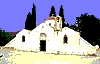 The three-aisle church of Panagia
Kera is built near the village of Kritsa, 10 km
south-west of Agios Nikolaos. The central
aisle is dedicated to Virgin Mary, while the
other two are dedicated to Agia Anna and
Agios Antonios. The church's present form has
been preserved since the 15th century, when
its construction was completed, with the
addition of the north aisle and the dome.
The church of Panagia Kera is known
for its precious Byzantine frescoes, dating
back in the 14th and 15th century. Among the
themes depicted here, are scenes from the
Garden of Eden, the life of Agia Anna, the
Theometoral circle, the Apocalypse, the
Annunciation and the Last Supper, all done in
beautiful and harmonic colours.
The three-aisle church of Panagia
Kera is built near the village of Kritsa, 10 km
south-west of Agios Nikolaos. The central
aisle is dedicated to Virgin Mary, while the
other two are dedicated to Agia Anna and
Agios Antonios. The church's present form has
been preserved since the 15th century, when
its construction was completed, with the
addition of the north aisle and the dome.
The church of Panagia Kera is known
for its precious Byzantine frescoes, dating
back in the 14th and 15th century. Among the
themes depicted here, are scenes from the
Garden of Eden, the life of Agia Anna, the
Theometoral circle, the Apocalypse, the
Annunciation and the Last Supper, all done in
beautiful and harmonic colours.
 The Diktaio Andron (‘cave’) is located
52 km west of Agios Nikolaos, at an altitude
of 1,025 m, on the north side of mount Dikta,
near the village of Psichros. In 1900, the
English archaeologist, D. Hoogarth,
discovered inside ceremonial altars,
architectural structures, statuettes, tables for
offerings weapons, tools, pottery, seals, jewels
and many other finds of great archaeological
significance, which indicate that during the
Middle-Minoan and Archaic Period, Dikteon
Andron was a shrine to Zeus. According to
myth, Rhea sought refuge there to protect
Zeus from Kronos' rage. This is where Zeus
grew up and drank the milk of goat Amalthia,
under the supervision of Kourites and
Nymphs and here is where he met Europe.
The cave's entrance (14x8 m) leads to
a large quarter (85x3x15 m) which is divided
in four smaller compartments, filled with
stalactites and stalagmites. In the
background, there's a small pond where,
according to myth, Zeus bathed and around
which most of the offerings were found.
The Diktaio Andron (‘cave’) is located
52 km west of Agios Nikolaos, at an altitude
of 1,025 m, on the north side of mount Dikta,
near the village of Psichros. In 1900, the
English archaeologist, D. Hoogarth,
discovered inside ceremonial altars,
architectural structures, statuettes, tables for
offerings weapons, tools, pottery, seals, jewels
and many other finds of great archaeological
significance, which indicate that during the
Middle-Minoan and Archaic Period, Dikteon
Andron was a shrine to Zeus. According to
myth, Rhea sought refuge there to protect
Zeus from Kronos' rage. This is where Zeus
grew up and drank the milk of goat Amalthia,
under the supervision of Kourites and
Nymphs and here is where he met Europe.
The cave's entrance (14x8 m) leads to
a large quarter (85x3x15 m) which is divided
in four smaller compartments, filled with
stalactites and stalagmites. In the
background, there's a small pond where,
according to myth, Zeus bathed and around
which most of the offerings were found.
 Mount Dikti, alias "Lassithiotika
Vouna", is situated at the western side of
Lassithi Prefecture. It is part of the
Dinarotauric Arrow, has an altitude of 2,148
m. and consists of peaks such as Afendis
Stavros or Agio Pnevma (1,578 m.),
Virgiomeno (1,414 m.), Afendis Christos or
Psari Madara (2,141 m.), Katharo Tsivi or
Aliada (1,664 m.), Lazarus (2,058 m.),
Louloudaki (1,163 m.), Koupa (1,187 m.),
Megali Korifi (1,141 m.) and Platia Korifi
(1,485 m.). These peaks form the plateau of
Lassithi (402 sq. km) and one can get there
from the villages of Agios Georgios and Male,
or the monastery of Croustallenia.
Mount Dikti, alias "Lassithiotika
Vouna", is situated at the western side of
Lassithi Prefecture. It is part of the
Dinarotauric Arrow, has an altitude of 2,148
m. and consists of peaks such as Afendis
Stavros or Agio Pnevma (1,578 m.),
Virgiomeno (1,414 m.), Afendis Christos or
Psari Madara (2,141 m.), Katharo Tsivi or
Aliada (1,664 m.), Lazarus (2,058 m.),
Louloudaki (1,163 m.), Koupa (1,187 m.),
Megali Korifi (1,141 m.) and Platia Korifi
(1,485 m.). These peaks form the plateau of
Lassithi (402 sq. km) and one can get there
from the villages of Agios Georgios and Male,
or the monastery of Croustallenia.
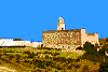
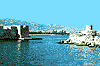 The fort of Ierapetra, known as KALES,
is located on the south pier of the ancient
harbour. According to historians, it was built
by the Venetians, probably in the early 13th
century. It was a four-sided building with
four towers on the corners and an indoor
yard with a reservoir. The rooms were spread
under the ramparts, as shown in older prints.
It was renovated and expanded during the
Turkish Occupation. Unfortunately, today,
little remains of the constructions and the
rooms of the top floors.
The fort of Ierapetra, known as KALES,
is located on the south pier of the ancient
harbour. According to historians, it was built
by the Venetians, probably in the early 13th
century. It was a four-sided building with
four towers on the corners and an indoor
yard with a reservoir. The rooms were spread
under the ramparts, as shown in older prints.
It was renovated and expanded during the
Turkish Occupation. Unfortunately, today,
little remains of the constructions and the
rooms of the top floors.
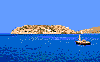
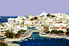 Lake Voulismeni or Xepatomeni is
situated at the entrance of the port of Agios
Nikolaos. According to mythology, here
bathed Diana and Athena. It is 60 - 64 m.
deep and its diameter is 137 m.
In the late 19th century, Adossides
Pasha linked the two sides of the lake, with a
bridge. Today, along the lake, there are
picturesque restaurants, taverns and coffee -
shops attracting large crowds in the summer,
while there is also a zoo near the southern
end of the lake.
Lake Voulismeni or Xepatomeni is
situated at the entrance of the port of Agios
Nikolaos. According to mythology, here
bathed Diana and Athena. It is 60 - 64 m.
deep and its diameter is 137 m.
In the late 19th century, Adossides
Pasha linked the two sides of the lake, with a
bridge. Today, along the lake, there are
picturesque restaurants, taverns and coffee -
shops attracting large crowds in the summer,
while there is also a zoo near the southern
end of the lake.
 The Laographic Museum of Ag.
Georgios is situated at the village of Agios
Georgios, in Lassithi plateau, 50 km west of
Agios Nikolaos. Here, one can tour the
remarkable collection of utensils of daily life,
tools, domestic items and woven-fabrics.
In carefully decorated rooms, there
are representations of a traditional workshop
of basket-knitting, barbershop etc., all
providing a multitude of information
regarding the daily life and traditions of
Cretan people.
The Laographic Museum of Ag.
Georgios is situated at the village of Agios
Georgios, in Lassithi plateau, 50 km west of
Agios Nikolaos. Here, one can tour the
remarkable collection of utensils of daily life,
tools, domestic items and woven-fabrics.
In carefully decorated rooms, there
are representations of a traditional workshop
of basket-knitting, barbershop etc., all
providing a multitude of information
regarding the daily life and traditions of
Cretan people.
 The Kapsa monastery, located 5 km
away from Analipsi, is built on a rock in a
steep ravine, near the famous gorge of
Perivolakia.
The monastery was renovated in 1841
by Gerontogiannis, a thief who took the vow
of monastic life here. Kapsa monastery
belongs to the monastery of Toplou and
celebrates on August 29th with a big fair.
The Kapsa monastery, located 5 km
away from Analipsi, is built on a rock in a
steep ravine, near the famous gorge of
Perivolakia.
The monastery was renovated in 1841
by Gerontogiannis, a thief who took the vow
of monastic life here. Kapsa monastery
belongs to the monastery of Toplou and
celebrates on August 29th with a big fair.
 The monastery of Toplou is located
83.5 km east of Agios Nikolaos. Dedicated to
the Birth of Virgin Mary and to St John the
Theologist, it is one of the richest monasteries
of the island. It was originally called Panagia
Akrotiriani (Virgin Mary of the Cape), because
of the nearby Sidero cape. It took its current
name by the Turks, because of its venetian
cannon (top). The monastery was built in the
15th century, probably on the ruins of an
earlier convent, it was plundered in 1530 by
the knights of Malta and ruined in 1612 by a
strong earthquake, to be renovated once
again, before coming under Turkish
Occupation in 1646.
The exterior is dominated by a tall,
Italian-style, bell-tower (1558) and a square
wall (10 m high) around it. On the church's
wall one can see an inscription of historic
importance, referring to the peace treaty
between the cities Itanos and Ierapitnos (2nd
century BC).
Inside the church, among other
beautiful icons and frescoes (14th century),
one can admire the famous picture "Great Art
Thou, O Lord" which was created in 1770 by
painter Ioannis Kornaros and the icon of Our
Lady which - according to legend - was found
in a nearby cave.
The monastery is closely associated
with the island's history. During the Turkish
Occupation, it provided refuge to the
persecuted Cretans and it housed a ‘Secret
School’, a fact which caused the massacre of
12 monks in 1866. In the years of German
Occupation, the monastery was used as the
headquarters for the National Resistance
movement of the area.
The monastery celebrates on
September 26th, when it is swarmed with
pilgrims from all over Crete.
The monastery of Toplou is located
83.5 km east of Agios Nikolaos. Dedicated to
the Birth of Virgin Mary and to St John the
Theologist, it is one of the richest monasteries
of the island. It was originally called Panagia
Akrotiriani (Virgin Mary of the Cape), because
of the nearby Sidero cape. It took its current
name by the Turks, because of its venetian
cannon (top). The monastery was built in the
15th century, probably on the ruins of an
earlier convent, it was plundered in 1530 by
the knights of Malta and ruined in 1612 by a
strong earthquake, to be renovated once
again, before coming under Turkish
Occupation in 1646.
The exterior is dominated by a tall,
Italian-style, bell-tower (1558) and a square
wall (10 m high) around it. On the church's
wall one can see an inscription of historic
importance, referring to the peace treaty
between the cities Itanos and Ierapitnos (2nd
century BC).
Inside the church, among other
beautiful icons and frescoes (14th century),
one can admire the famous picture "Great Art
Thou, O Lord" which was created in 1770 by
painter Ioannis Kornaros and the icon of Our
Lady which - according to legend - was found
in a nearby cave.
The monastery is closely associated
with the island's history. During the Turkish
Occupation, it provided refuge to the
persecuted Cretans and it housed a ‘Secret
School’, a fact which caused the massacre of
12 monks in 1866. In the years of German
Occupation, the monastery was used as the
headquarters for the National Resistance
movement of the area.
The monastery celebrates on
September 26th, when it is swarmed with
pilgrims from all over Crete.
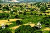 The plateau of Lassithi is one of the
most beautiful areas in Crete. It is a green,
fertile valley (817 m. altitude), covering an
extension of 25,000 sq. km. full of cultivation
of potatoes, garden and fruit products and
almond - trees. The scenery's beauty is
completed with the 10,000 windmills which
are scattered here for the area's watering.
The territory consists of 20 villages, while the
capital village of Tzermiado has 1,000
inhabitants.
Excavations at Diktaion Andron cave,
at Trapeza cave, at Karfi and Plati, indicate
that the area has been inhabited ever since
the Neolithic Period. Later in the years, it was
part of the ancient city of Littos which thrived.
During the Cretan fight for liberty, during the
Venetian Rule and Turkish Occupation,
Lassithi plateau provided refuge to the
persecuted fighters, a fact which forced the
Venetians, in 1263, to forbid all establishment
and cultivation in the area.
The plateau of Lassithi is one of the
most beautiful areas in Crete. It is a green,
fertile valley (817 m. altitude), covering an
extension of 25,000 sq. km. full of cultivation
of potatoes, garden and fruit products and
almond - trees. The scenery's beauty is
completed with the 10,000 windmills which
are scattered here for the area's watering.
The territory consists of 20 villages, while the
capital village of Tzermiado has 1,000
inhabitants.
Excavations at Diktaion Andron cave,
at Trapeza cave, at Karfi and Plati, indicate
that the area has been inhabited ever since
the Neolithic Period. Later in the years, it was
part of the ancient city of Littos which thrived.
During the Cretan fight for liberty, during the
Venetian Rule and Turkish Occupation,
Lassithi plateau provided refuge to the
persecuted fighters, a fact which forced the
Venetians, in 1263, to forbid all establishment
and cultivation in the area.
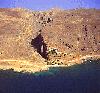
 Spinalonga is a small islet, across the
water from Elounda. Here, in antiquity, stood
the powerful acropolis of the ancient town of
Olounda. The islet was named "Spinalonga",
some say, by the Venetians (Spina = thorns,
Longa = away), while another version claims
that it was named after the local expression
"Stinelonda" (at Elounda).
The islet of Spinalonga was
supposedly joined with the land across, until
- for reason of safety - the Venetians detached
it by digging a deep trench. On the peninsula
which is linked to the main land by the Poros
isthmus, constructed by the French in 1897,
there are traces of the ancient city of
Olounda, an altar of the Geometric Period
and ruins of a Proto-byzantine basilica with a
remarkable mosaic floor.
In 1579, the Venetians built here an
invincible castle which, according to
historians, had 35 cannons in 1630. Although
Crete came under the Turkish Occupation in
1669, Spinalonga remained under Venetian
Rule until 1715, when it was released to the
Turk, Kapoudan Pasha. In the years of
Venetian Rule, the islet provided refuge to
the persecuted Christians. From 1903 and for
half a century - until 1957 - it was a leper
colony. In 1954, the islet was named
"Kalidonia". Today, among the remaining
buildings of the castle, one can see the
rampart of Mogenigo, the front wall of San
Michele, as well as ruins of Turkish houses.
Spinalonga is a small islet, across the
water from Elounda. Here, in antiquity, stood
the powerful acropolis of the ancient town of
Olounda. The islet was named "Spinalonga",
some say, by the Venetians (Spina = thorns,
Longa = away), while another version claims
that it was named after the local expression
"Stinelonda" (at Elounda).
The islet of Spinalonga was
supposedly joined with the land across, until
- for reason of safety - the Venetians detached
it by digging a deep trench. On the peninsula
which is linked to the main land by the Poros
isthmus, constructed by the French in 1897,
there are traces of the ancient city of
Olounda, an altar of the Geometric Period
and ruins of a Proto-byzantine basilica with a
remarkable mosaic floor.
In 1579, the Venetians built here an
invincible castle which, according to
historians, had 35 cannons in 1630. Although
Crete came under the Turkish Occupation in
1669, Spinalonga remained under Venetian
Rule until 1715, when it was released to the
Turk, Kapoudan Pasha. In the years of
Venetian Rule, the islet provided refuge to
the persecuted Christians. From 1903 and for
half a century - until 1957 - it was a leper
colony. In 1954, the islet was named
"Kalidonia". Today, among the remaining
buildings of the castle, one can see the
rampart of Mogenigo, the front wall of San
Michele, as well as ruins of Turkish houses.


http://www.areianet.gr/infoxenios/
