


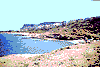
AGIA FOTIA
 This seaside village is located about
53 km. southeast of St. Nicolas (Agios
Nikolaos). The area exhibits the most
beautiful sites in the County, with beautiful
coves which attract many visitors in the
summer.
The archaeologist, mr. K. Davaras has brought
to light the nearby ancient cemetary, with 250
tombs of the protominoan age, as well as a
number of artifacts of great historical value.
This seaside village is located about
53 km. southeast of St. Nicolas (Agios
Nikolaos). The area exhibits the most
beautiful sites in the County, with beautiful
coves which attract many visitors in the
summer.
The archaeologist, mr. K. Davaras has brought
to light the nearby ancient cemetary, with 250
tombs of the protominoan age, as well as a
number of artifacts of great historical value.
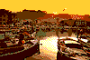
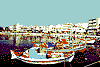
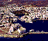 The town of Agios Nikolaos, built on
the bay of Mirabelo, is the Capital of the
County of Lassithi. According to
archaeologists, this was the site of the ancient
town of Lato or Hetera, which prospered
during the 3rd century B.C. In the 16th
century, the Venetians gave it its modern
name in honour of the small church of St.
Nicolas, built in the 8th or 9th century. The
Mirabelo castle was built at the same time,
giving its name to the Bay.
Agios Nikolaos is a beautiful town of about
8.500 residents, and it is the centre of much
of the financial and public administration life
of the island. Its warm climate as well as its
beautiful beaches have turned the area into a
famed tourist resort, attracting great
numbers of visitors in the summer. The town
is full of shops, restraurants, little tavernas,
traditional coffee houses, pubs and hotels. In
spite of the booming tourist industry, the
traditional profile of the town remains intact.
Narrow stone laid alleys and squares,
traditional homes, coming down to the leka
Voulismeni, at the entrance of the harbour,
are among the sites worth seeing. Also worth
visiting are the Archaelogical and Laographic
Museum as well as the "Koundourios"
Municipal Library.
From the port of Agios Nikolaos you will
find easy access by fishing boats to
cosmopolitan Elounda and to the isle of
Spinaloga.
The town of Agios Nikolaos, built on
the bay of Mirabelo, is the Capital of the
County of Lassithi. According to
archaeologists, this was the site of the ancient
town of Lato or Hetera, which prospered
during the 3rd century B.C. In the 16th
century, the Venetians gave it its modern
name in honour of the small church of St.
Nicolas, built in the 8th or 9th century. The
Mirabelo castle was built at the same time,
giving its name to the Bay.
Agios Nikolaos is a beautiful town of about
8.500 residents, and it is the centre of much
of the financial and public administration life
of the island. Its warm climate as well as its
beautiful beaches have turned the area into a
famed tourist resort, attracting great
numbers of visitors in the summer. The town
is full of shops, restraurants, little tavernas,
traditional coffee houses, pubs and hotels. In
spite of the booming tourist industry, the
traditional profile of the town remains intact.
Narrow stone laid alleys and squares,
traditional homes, coming down to the leka
Voulismeni, at the entrance of the harbour,
are among the sites worth seeing. Also worth
visiting are the Archaelogical and Laographic
Museum as well as the "Koundourios"
Municipal Library.
From the port of Agios Nikolaos you will
find easy access by fishing boats to
cosmopolitan Elounda and to the isle of
Spinaloga.
 The tourist area of Elounda, which
consists of 7 smaller communities, is located
at about 11 km. north of Agios Nikolaos. The
seaside resort, Shisma, may be the most
developed of the kind in Greece. Along its
beaches you will find a number of hotel
complexes, restaurants and nigh clubs,
attracting great numbers of visitors in the
summer. It is believed that this was the site
of ancient Olounda or Olous, ruins of which
have been found underwater.
From Elounda you will have the opportunity
to visit by boat the nearby isle of Spinaloga, as
well as the Spinaloga Cape. Also in the area,
the monasteries of Agios Eratios and Xiron
Xilon.
The tourist area of Elounda, which
consists of 7 smaller communities, is located
at about 11 km. north of Agios Nikolaos. The
seaside resort, Shisma, may be the most
developed of the kind in Greece. Along its
beaches you will find a number of hotel
complexes, restaurants and nigh clubs,
attracting great numbers of visitors in the
summer. It is believed that this was the site
of ancient Olounda or Olous, ruins of which
have been found underwater.
From Elounda you will have the opportunity
to visit by boat the nearby isle of Spinaloga, as
well as the Spinaloga Cape. Also in the area,
the monasteries of Agios Eratios and Xiron
Xilon.
 Ierapetra is located at a distance of
about 35 km. south of Agios Nikolaos, and is
has the most population of any other city in
southern Crete. As it is proven by
archaeological excavations, the city is built at
the site of the ancient city of Ierapitna, which
flourished during the 2nd century B.C. After
the year 66 A.D. and all during the roman
age, the city kept its eminence and was the
strongest in the area. In the 13 century A.D.
it was taken over by the Genovese, who built
its fortress, known as Castle Gerapetra, and
as Castelli or Koule to the locals. It was later
taken over by the Venetians, who concluded
the works for the fortification of the city.
Today, the city of Ierapetra has about 11.000
residents who mainly live off agriculture and
tourism. The city is surrounded by many
cultivations of groceries and orange or lemon
groves, which are veruy productive due to the
innumerous days of sunshine and the warm
climate. In the town you will find a
worthwhile archaeological exhibition, with all
the artifacts found in the area. Worth seeing
are also the Mosque in the turkish
neighbourhood of the old city, the Churches
of of the Metamorhosis of Christ (14th
century A.D.) of Agios Nikolaos, of Agios
Ioanniw, of Agios Georgios (1856) as well
as the Church of Panagitsa or Panagitsa of
Kale opposite the fortress.
From Ierapetra yoy may visit the village of
Vasiliki, where have been found ruins of a
protominoan village (2600 - 2300 B.C.) or the
small island of Chrisi.
Ierapetra is located at a distance of
about 35 km. south of Agios Nikolaos, and is
has the most population of any other city in
southern Crete. As it is proven by
archaeological excavations, the city is built at
the site of the ancient city of Ierapitna, which
flourished during the 2nd century B.C. After
the year 66 A.D. and all during the roman
age, the city kept its eminence and was the
strongest in the area. In the 13 century A.D.
it was taken over by the Genovese, who built
its fortress, known as Castle Gerapetra, and
as Castelli or Koule to the locals. It was later
taken over by the Venetians, who concluded
the works for the fortification of the city.
Today, the city of Ierapetra has about 11.000
residents who mainly live off agriculture and
tourism. The city is surrounded by many
cultivations of groceries and orange or lemon
groves, which are veruy productive due to the
innumerous days of sunshine and the warm
climate. In the town you will find a
worthwhile archaeological exhibition, with all
the artifacts found in the area. Worth seeing
are also the Mosque in the turkish
neighbourhood of the old city, the Churches
of of the Metamorhosis of Christ (14th
century A.D.) of Agios Nikolaos, of Agios
Ioanniw, of Agios Georgios (1856) as well
as the Church of Panagitsa or Panagitsa of
Kale opposite the fortress.
From Ierapetra yoy may visit the village of
Vasiliki, where have been found ruins of a
protominoan village (2600 - 2300 B.C.) or the
small island of Chrisi.
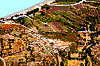
 The "head" village of Kritsas has
about 2.100 residents and is located at a
distance of 10 km. southwest of Agios
Nikolaos. It is built on a hill and has a
panoramic view of the area around it. This is
one of the most beuatiful villages of Crete,
with its narrow streets and the houses os
traditional architecture.
The villagers live off agriculture as well as the
production of artifacts, knitted items,
embroideries, pottery. Near Kritsa you will
find th Church of Panagia Keras, built in the
15 century.
Starting out from Kritsa, it is worthwhile to
visit the site of the excavations of the doric
city of "Lato Hetera" which thrived during
the 1st,. millenium B.C.
The "head" village of Kritsas has
about 2.100 residents and is located at a
distance of 10 km. southwest of Agios
Nikolaos. It is built on a hill and has a
panoramic view of the area around it. This is
one of the most beuatiful villages of Crete,
with its narrow streets and the houses os
traditional architecture.
The villagers live off agriculture as well as the
production of artifacts, knitted items,
embroideries, pottery. Near Kritsa you will
find th Church of Panagia Keras, built in the
15 century.
Starting out from Kritsa, it is worthwhile to
visit the site of the excavations of the doric
city of "Lato Hetera" which thrived during
the 1st,. millenium B.C.
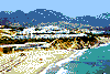 The seaside resort village of
Makrigialos is located 63 km. southeast of St.
Nicolas (Agios Nikolaos) , built at the centre
of the Kala Nera Bay, an area which is full of
greenhouse cultivations. Its wonderful sandy
beaches and its crystal clear waters attract
great numbers of visitors during the summer
months, allowing the area to evolve into one
of the most important resorts on the island.
A minoan age mansion was discovered in the
village, exhibiting important archaeological
findings, which are kept at the St. Nicolas
Archaeological Museum.
From Makrigialos you may visit the nearby
monastery of St. John Kapsa.
The seaside resort village of
Makrigialos is located 63 km. southeast of St.
Nicolas (Agios Nikolaos) , built at the centre
of the Kala Nera Bay, an area which is full of
greenhouse cultivations. Its wonderful sandy
beaches and its crystal clear waters attract
great numbers of visitors during the summer
months, allowing the area to evolve into one
of the most important resorts on the island.
A minoan age mansion was discovered in the
village, exhibiting important archaeological
findings, which are kept at the St. Nicolas
Archaeological Museum.
From Makrigialos you may visit the nearby
monastery of St. John Kapsa.
 Milatos has about 400 residents and
is located at a distance of 32.5 km. northwest
of Agios Nikolaos. Here we have two
communities, the seaside Milatos and inland
Milatos, built at the site of the homonymous
minoan city found there until the 3rd century
B.C., which was destroyed by enemy town
Lyto. According to mythology, the town was
named after Milatos, a boy raised by a wolf,
who as a teenager killed the local tyrant
freeing the people from oppression. Legend
has it that Milatos was also the founder of
cretan colony Militou in Asia Minor.
Worth visiting near the village of Milatos is
the homonymous Cave, with exquisite
stalactites and stalagmites. Next to the Caves
you will notice the small church of St.
Thomas, built in memory of the 3.600 Cretans
who were massacred in 1823 at this site by
the Turk, Hasan.
Milatos has about 400 residents and
is located at a distance of 32.5 km. northwest
of Agios Nikolaos. Here we have two
communities, the seaside Milatos and inland
Milatos, built at the site of the homonymous
minoan city found there until the 3rd century
B.C., which was destroyed by enemy town
Lyto. According to mythology, the town was
named after Milatos, a boy raised by a wolf,
who as a teenager killed the local tyrant
freeing the people from oppression. Legend
has it that Milatos was also the founder of
cretan colony Militou in Asia Minor.
Worth visiting near the village of Milatos is
the homonymous Cave, with exquisite
stalactites and stalagmites. Next to the Caves
you will notice the small church of St.
Thomas, built in memory of the 3.600 Cretans
who were massacred in 1823 at this site by
the Turk, Hasan.
 The picturesque seaside resort of Sissi
is located at a distance of 21 km. northwest
of Agios Nikolaos. The about 400 residents
of the village mainly live off tourism, since
the exquisite sandy beach of the resort attract
many tourists during the summer months,
causing Sisi to become one of the best known
tourist centers on the island.
The picturesque seaside resort of Sissi
is located at a distance of 21 km. northwest
of Agios Nikolaos. The about 400 residents
of the village mainly live off tourism, since
the exquisite sandy beach of the resort attract
many tourists during the summer months,
causing Sisi to become one of the best known
tourist centers on the island.
 The city of Sitia, with 8.500 residents,
is built at the center of a quiet and
picturesque cove, at a distance of 69 km. east
of Agios Nikolaos. According to
archaelogists, it is located at the site of the
ancient town of Itia, the porrt of Presos and
the birthplace of "wise Myson". As it is
proven by the excavations at the Mohlo area
and on the little island of Psira, the town
flourished during the minoan age.
The contemporary town of Sitia was built in
1870, on the architectural plans of Avgi
Pasha, after two centuries of almost complete
desertion (1651 - 1870). Among its buildings
you will notice parts of the fortified wall and
of the castle of Kazarma, which were built by
the Venetians and were destroyed during the
earthquakes of 1303 and 1508, as well as the
bombardment of the town from the pirate
Barbarossa, in 1538. Sitia is also known as
the birthplace of the poet Vintsezos Kornaros,
the composer of "Erotokritos". Worth
visisting in the town are the Church of the
Analipsis of Sotira, the Archaelogical
Museum, which opened its doors in 1984,
and the Laographic Museum, where you will
find lots of information about the daily life
and the tradition of the area.
From Sitia, you can visit the ruins of the
ancient city of Presos, at a distance of 15 km.
south of the town, the Hamezi area where has
been located a structure of the mid-minoan
and the ancient-empire period as well as the
Monasteries of Faneromeni and Toplou.
The city of Sitia, with 8.500 residents,
is built at the center of a quiet and
picturesque cove, at a distance of 69 km. east
of Agios Nikolaos. According to
archaelogists, it is located at the site of the
ancient town of Itia, the porrt of Presos and
the birthplace of "wise Myson". As it is
proven by the excavations at the Mohlo area
and on the little island of Psira, the town
flourished during the minoan age.
The contemporary town of Sitia was built in
1870, on the architectural plans of Avgi
Pasha, after two centuries of almost complete
desertion (1651 - 1870). Among its buildings
you will notice parts of the fortified wall and
of the castle of Kazarma, which were built by
the Venetians and were destroyed during the
earthquakes of 1303 and 1508, as well as the
bombardment of the town from the pirate
Barbarossa, in 1538. Sitia is also known as
the birthplace of the poet Vintsezos Kornaros,
the composer of "Erotokritos". Worth
visisting in the town are the Church of the
Analipsis of Sotira, the Archaelogical
Museum, which opened its doors in 1984,
and the Laographic Museum, where you will
find lots of information about the daily life
and the tradition of the area.
From Sitia, you can visit the ruins of the
ancient city of Presos, at a distance of 15 km.
south of the town, the Hamezi area where has
been located a structure of the mid-minoan
and the ancient-empire period as well as the
Monasteries of Faneromeni and Toplou.
 The unique Vai palm-forest lies 92 km
east of Agios Nikolaos and occupies an area
of 250 square km. Its unique beauty is
reminiscent of tropical locations, as 5,000
palm-trees extend for two miles and reach
the beautiful golden beach which attracts
scores of swimmers in summer. It is the
largest known palm-tree forest throughout
Europe. According to a local legend,
Phoenician merchants arrived here and threw
date-seeds, which produced the famous
palm-trees (vagia), after which the area was
named.
The unique Vai palm-forest lies 92 km
east of Agios Nikolaos and occupies an area
of 250 square km. Its unique beauty is
reminiscent of tropical locations, as 5,000
palm-trees extend for two miles and reach
the beautiful golden beach which attracts
scores of swimmers in summer. It is the
largest known palm-tree forest throughout
Europe. According to a local legend,
Phoenician merchants arrived here and threw
date-seeds, which produced the famous
palm-trees (vagia), after which the area was
named.
 The village of Zakros or Epano Zakros
is located at a distance of 108 km. southeast
of Agios Nikolaos. It is built in an area full
of orange groves and olive trees, at the side
of two hills. The whitewashed houses of the
village, with their beautiful gardens, give it a
unique grace.
From Zakro yoy have easy access to the
archaelogical excavations site of seaside Kato
Zakro, where an importan ancient village and
a minoan age mansion have been found.
The village of Zakros or Epano Zakros
is located at a distance of 108 km. southeast
of Agios Nikolaos. It is built in an area full
of orange groves and olive trees, at the side
of two hills. The whitewashed houses of the
village, with their beautiful gardens, give it a
unique grace.
From Zakro yoy have easy access to the
archaelogical excavations site of seaside Kato
Zakro, where an importan ancient village and
a minoan age mansion have been found.


http://www.areianet.gr/infoxenios/
