


 Kea, or Gia, is the northern most island of the Western Cyclades. It lies between Kithnos and Evia and is 131 sq km in area. This almond shaped island is 81 km in coastline. It is 16 nautical
miles from Lavrio and 40 from Piraeus.
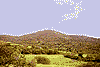
It is a mountainous island with Profitis Ilias (568 metres) as its highest peak. Among the mountains are narrow valleys, of which the
most representative are Pisses, Milopotamos and Ogias. The island's subsoil is rich in slate, marble and minerals, mainly iron and manganese compounds.
The stream of Milopotamos traverses the valley of the same name and has been the only sign of running water in the area since ancient times.
On the mainland, the vegetation is quite lush. There are plenty of almond trees, circus and other fruit trees and "royal oaks" from which big forests are created. The island has a great variety of indigenous plants and herbs, like the famous hemlock. Kea
is rich in fowl fauna, such as robins as well as partridges.
The island's climate is typically mild with cool summers. The range of rainfalls is limited, but compared to the rest of the Cyclades, is quite high. During winter, it snows quite regularly.
The 1,800 inhabitants of Kea are mainly engaged in agriculture and stock-breeding and only a few of them live off tourism.
Kea, or Gia, is the northern most island of the Western Cyclades. It lies between Kithnos and Evia and is 131 sq km in area. This almond shaped island is 81 km in coastline. It is 16 nautical
miles from Lavrio and 40 from Piraeus.
It is a mountainous island with Profitis Ilias (568 metres) as its highest peak. Among the mountains are narrow valleys, of which the
most representative are Pisses, Milopotamos and Ogias. The island's subsoil is rich in slate, marble and minerals, mainly iron and manganese compounds.
The stream of Milopotamos traverses the valley of the same name and has been the only sign of running water in the area since ancient times.
On the mainland, the vegetation is quite lush. There are plenty of almond trees, circus and other fruit trees and "royal oaks" from which big forests are created. The island has a great variety of indigenous plants and herbs, like the famous hemlock. Kea
is rich in fowl fauna, such as robins as well as partridges.
The island's climate is typically mild with cool summers. The range of rainfalls is limited, but compared to the rest of the Cyclades, is quite high. During winter, it snows quite regularly.
The 1,800 inhabitants of Kea are mainly engaged in agriculture and stock-breeding and only a few of them live off tourism.


http://www.areianet.gr/infoxenios/
