


 Kithnos, or Thermia as it is called by the locals, lies between Gia and Serifos and is 54 nautical miles from Piraeus. It belongs to the province of Kea of the prefecture of the Cyclades and is 99.2 sq km.
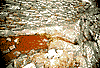
Its soil is rocky and its highest peak is Profitis Ilias (336 metres). At Kokovolo, Lefkes and the Zogaki locations, there are abandoned manganese iron and lead mines. There are also medicinal springs in Loutra and Apokroussi, with sulphur, saline, and ferrous waters, which treat rheumatism and arthritis.
The climate of Kithnos is dry with cool summers. The climate favours cultivation, but the barren soil does not. So the main production of the island is stock-breeding products, such as the famous "Thermiot" cheese from antiquity. Other products of Kithnos are barley, fine honey, almonds, figs, and garden produce, which cover local needs only.
The 1,500 inhabitants of Kithnos are mainly employed in stock-breeding, fishing and agriculture and much less in tourism. They are easy-going and cheerful people. They love to organise festivals and are always eager to attend to visitors of their island.
Kithnos, or Thermia as it is called by the locals, lies between Gia and Serifos and is 54 nautical miles from Piraeus. It belongs to the province of Kea of the prefecture of the Cyclades and is 99.2 sq km.
Its soil is rocky and its highest peak is Profitis Ilias (336 metres). At Kokovolo, Lefkes and the Zogaki locations, there are abandoned manganese iron and lead mines. There are also medicinal springs in Loutra and Apokroussi, with sulphur, saline, and ferrous waters, which treat rheumatism and arthritis.
The climate of Kithnos is dry with cool summers. The climate favours cultivation, but the barren soil does not. So the main production of the island is stock-breeding products, such as the famous "Thermiot" cheese from antiquity. Other products of Kithnos are barley, fine honey, almonds, figs, and garden produce, which cover local needs only.
The 1,500 inhabitants of Kithnos are mainly employed in stock-breeding, fishing and agriculture and much less in tourism. They are easy-going and cheerful people. They love to organise festivals and are always eager to attend to visitors of their island.


http://www.areianet.gr/infoxenios/
