


 Milos is the fifth largest island in the Cyclades. It occupies the south-west extremity and is 150.6 sq km in area. It is the centre of the prefecture of the same name and is 86 nautical miles from Piraeus.
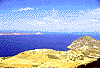
The horseshoe shaped island has a wide bay which is one of the largest natural harbours in the Mediterranean. It is one of the lowest Cycladian islands, with the exception of it highest peak, mount Profitis Ilias (773 metres). Milos has volcanic origins and its surface has been transformed many times by volcanic eruptions. Its hot
medicinal springs are a result of these eruptions.
The plain of Hora is fertile, but its small kitchen gardens and olive groves, which give colour to the volcanic landscape, cover only local needs.
The 4,500 inhabitants of Milos live off stock-breeding, fishing and tourism. Their spontaneous, open-hearted nature contrasts sharply with the rough and wild landscape.
Milos is 5 nautical miles from Antimilos, or Erimomilos. This islet has been proclaimed a national park because of its chamois, a rare species of wild goat of brown colour with a black stripe on its back which faces great survival problems.
Milos is the fifth largest island in the Cyclades. It occupies the south-west extremity and is 150.6 sq km in area. It is the centre of the prefecture of the same name and is 86 nautical miles from Piraeus.
The horseshoe shaped island has a wide bay which is one of the largest natural harbours in the Mediterranean. It is one of the lowest Cycladian islands, with the exception of it highest peak, mount Profitis Ilias (773 metres). Milos has volcanic origins and its surface has been transformed many times by volcanic eruptions. Its hot
medicinal springs are a result of these eruptions.
The plain of Hora is fertile, but its small kitchen gardens and olive groves, which give colour to the volcanic landscape, cover only local needs.
The 4,500 inhabitants of Milos live off stock-breeding, fishing and tourism. Their spontaneous, open-hearted nature contrasts sharply with the rough and wild landscape.
Milos is 5 nautical miles from Antimilos, or Erimomilos. This islet has been proclaimed a national park because of its chamois, a rare species of wild goat of brown colour with a black stripe on its back which faces great survival problems.


http://www.areianet.gr/infoxenios/
