


 Sandorini has a total surface area of 76 sq. km, while the coastal length is 70 km and its distance from Piraeus is 128 n.m. It consists of the main island, Thira, which has the shape of a pedal, consisting of the smaller island of Thirassia and the islet of Aspronissi. The three main islands are linked with two others, Palia Kammeni and Nea Kammeni, where the crater of the volcano is situated.
The island's highest peak is Profitis Ilias (550 m.), while other peaks are Garvrilos, Megalo Vouno, Messa Vouno and Mikros Profitis Ilias.
The island has almost no water and the locals collect rain water in cistern for daily use. In four areas of Sandorini, there are thermomineral springs: Thermi, Plaka, Kokkina Nera and Anavritos.
The climate of Sandorini is mild with cool summer and warm winters. Rain is frequent in the water and rare in the summer.
The island has had volcanic activity for thousands of years. The volcanic eruptions created the island which was originally called "Stroggili" from its shape ( stroggilos: round ). In 1,500 BC, the volcano's strongest eruption sank the largest part of the island, thus creating the biggest pave in the world.
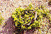
The only vegetation of the island consists of vineyards in the shape of a basket, protecting the grapes from the strong winds. These produce the famous wine of Sandorini. Sandorini is also known for its "fava" and for the small tomatoes which produce excellent tomato juice, or "bertes", as the locals call it. "Chloro", a cheese made of goat-milk, is also famous. Apart from the agricultural products, Sandorini's only exports is a mineral, called "Thiraiki Gri".
Sandorini has a population of 8,000 inhabitants, most of whom are occupied with tourism, as the tourists "swarm" to the island in the summer. The locals are hospitable and polite, cheerful and helpful. They love strangers and have done their best to make tourists feel at home.
Sandorini has a total surface area of 76 sq. km, while the coastal length is 70 km and its distance from Piraeus is 128 n.m. It consists of the main island, Thira, which has the shape of a pedal, consisting of the smaller island of Thirassia and the islet of Aspronissi. The three main islands are linked with two others, Palia Kammeni and Nea Kammeni, where the crater of the volcano is situated.
The island's highest peak is Profitis Ilias (550 m.), while other peaks are Garvrilos, Megalo Vouno, Messa Vouno and Mikros Profitis Ilias.
The island has almost no water and the locals collect rain water in cistern for daily use. In four areas of Sandorini, there are thermomineral springs: Thermi, Plaka, Kokkina Nera and Anavritos.
The climate of Sandorini is mild with cool summer and warm winters. Rain is frequent in the water and rare in the summer.
The island has had volcanic activity for thousands of years. The volcanic eruptions created the island which was originally called "Stroggili" from its shape ( stroggilos: round ). In 1,500 BC, the volcano's strongest eruption sank the largest part of the island, thus creating the biggest pave in the world.
The only vegetation of the island consists of vineyards in the shape of a basket, protecting the grapes from the strong winds. These produce the famous wine of Sandorini. Sandorini is also known for its "fava" and for the small tomatoes which produce excellent tomato juice, or "bertes", as the locals call it. "Chloro", a cheese made of goat-milk, is also famous. Apart from the agricultural products, Sandorini's only exports is a mineral, called "Thiraiki Gri".
Sandorini has a population of 8,000 inhabitants, most of whom are occupied with tourism, as the tourists "swarm" to the island in the summer. The locals are hospitable and polite, cheerful and helpful. They love strangers and have done their best to make tourists feel at home.


http://www.areianet.gr/infoxenios/
