


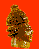
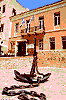
 The Archaeological Museum of Hania
was established in 1963 and is housed in the
venetian monastery of Agios Fragiscos. Here,
one can see finds brought to light by
excavations in western Crete, such as
domestic utensils, statues, pots, icons, seals,
jewels, mosaic floors, etc. dating back in the
Neo-Lithic, Early Minoan, Middle-Minoan,
Post-Minoan and Roman Period.
The Archaeological Museum of Hania
was established in 1963 and is housed in the
venetian monastery of Agios Fragiscos. Here,
one can see finds brought to light by
excavations in western Crete, such as
domestic utensils, statues, pots, icons, seals,
jewels, mosaic floors, etc. dating back in the
Neo-Lithic, Early Minoan, Middle-Minoan,
Post-Minoan and Roman Period.
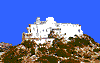 The convent of Chrissoskalitissa is
located 72 km south-west of Hania, built on
a steep rock, with a terrific view of the sea
below. To enter the convent, one must climb
90 steps one of which - as legend claims - is
golden (chrisso), but it is visible only to those
who have never committed a sin. Yet, there
are other legends regarding the name of the
convent. It is said that monks hid the
monastery's gold in a step so as to protect it
from the Turks, that Catherine donated a
golden step to the convent, or that the
monastery was named after the golden
carved icon of Virgin Mary, which is at least
1,000 years old.
The date of its construction is not
known. What is known is, that in 1897, after
expanding an old church structure, built in a
cave, the convent's altar was built and
dedicated to the Holy Trinity and to the
Assumption of the Virgin.
The convent of Chrissoskalitissa is
located 72 km south-west of Hania, built on
a steep rock, with a terrific view of the sea
below. To enter the convent, one must climb
90 steps one of which - as legend claims - is
golden (chrisso), but it is visible only to those
who have never committed a sin. Yet, there
are other legends regarding the name of the
convent. It is said that monks hid the
monastery's gold in a step so as to protect it
from the Turks, that Catherine donated a
golden step to the convent, or that the
monastery was named after the golden
carved icon of Virgin Mary, which is at least
1,000 years old.
The date of its construction is not
known. What is known is, that in 1897, after
expanding an old church structure, built in a
cave, the convent's altar was built and
dedicated to the Holy Trinity and to the
Assumption of the Virgin.
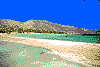 The islet of Elafonissi is situated 77
km south-west of Hania, opposite the
monastery of Chrissoskalitissa. One can get
there on foot, as the sea between it and the
land of Crete is shallow, 100 m. wide and
800 m. long. The islet's beautiful beaches
attract many tourists in the summer. A marble
sign reminds visitors that in April 24th 1824
on Easter Day, Hebraem' s Turkish army
massacred 600 Cretan fighters, women and
children.
The islet of Elafonissi is situated 77
km south-west of Hania, opposite the
monastery of Chrissoskalitissa. One can get
there on foot, as the sea between it and the
land of Crete is shallow, 100 m. wide and
800 m. long. The islet's beautiful beaches
attract many tourists in the summer. A marble
sign reminds visitors that in April 24th 1824
on Easter Day, Hebraem' s Turkish army
massacred 600 Cretan fighters, women and
children.
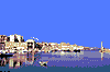 Fort Firkas is in the Topanas
neighbourhood in Hania, where the wealthy
Christian families lived, during the Turkish
Occupation. Firkas (military unit) was built in
1629 and is considered a significant historic
monument for Crete. In February 16th 1897,
the flag of the Great Powers was raised here,
pronouncing Crete's autonomy. At the same
place, 16 years later, on December 1st 1913,
Eleftherios Venizelos witnessed the island's
union with the rest of Greece. Today, the fort
houses the city's Naval Museum and a small,
summer theatre.
Before Firkas lies the Venetian port
and the wonderful beacon which was built in
the 16th century by the Venetians and
restored in 1830-40 by the Egyptians.
Fort Firkas is in the Topanas
neighbourhood in Hania, where the wealthy
Christian families lived, during the Turkish
Occupation. Firkas (military unit) was built in
1629 and is considered a significant historic
monument for Crete. In February 16th 1897,
the flag of the Great Powers was raised here,
pronouncing Crete's autonomy. At the same
place, 16 years later, on December 1st 1913,
Eleftherios Venizelos witnessed the island's
union with the rest of Greece. Today, the fort
houses the city's Naval Museum and a small,
summer theatre.
Before Firkas lies the Venetian port
and the wonderful beacon which was built in
the 16th century by the Venetians and
restored in 1830-40 by the Egyptians.
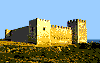 The Venetian castle "Fragokastello"
stands 88 km south-east of Hania, in an area
of unique natural beauty. It was built in 1371
by the Venetians for the protection of their
property from the pirates and the poor, local
farmers. Some say, its name derives from the
local phrase "Kastelli Fragon" (The Castle of
the Franks), while, others claim, it derives
from the Italian phrase "Castel Franco" (Brave
Castle).
The castle's exterior is very
impressive with the rectangular shape and the
four towers, one at every corner. At the main
entrance, one can see the carved lion of St
Marcus, symbol of Venice, as well as the
coats-of-arms of the Quirini and Dolfin
families.
Within a small distance from
Fragokastello, there are ruins of the Byzantine
churches of Agios Nikitas and Agios
Haralambos.
Fragokastello is associated with an
unexplainable phenomenon that takes place
in late May - early June, early in the morning.
The shadows of men, dressed in black appear
from the chapel of Agios Haralambos and
move toward the castle. Legend says they are
the famous "Drossoulites," soldiers of the
army of Dalianis who was defeated by the
Turks, in this area, in May 17th 1828 and who
still comes back to bravely confront the
enemy. According to science, this is only a
mirage phenomenon.
The Venetian castle "Fragokastello"
stands 88 km south-east of Hania, in an area
of unique natural beauty. It was built in 1371
by the Venetians for the protection of their
property from the pirates and the poor, local
farmers. Some say, its name derives from the
local phrase "Kastelli Fragon" (The Castle of
the Franks), while, others claim, it derives
from the Italian phrase "Castel Franco" (Brave
Castle).
The castle's exterior is very
impressive with the rectangular shape and the
four towers, one at every corner. At the main
entrance, one can see the carved lion of St
Marcus, symbol of Venice, as well as the
coats-of-arms of the Quirini and Dolfin
families.
Within a small distance from
Fragokastello, there are ruins of the Byzantine
churches of Agios Nikitas and Agios
Haralambos.
Fragokastello is associated with an
unexplainable phenomenon that takes place
in late May - early June, early in the morning.
The shadows of men, dressed in black appear
from the chapel of Agios Haralambos and
move toward the castle. Legend says they are
the famous "Drossoulites," soldiers of the
army of Dalianis who was defeated by the
Turks, in this area, in May 17th 1828 and who
still comes back to bravely confront the
enemy. According to science, this is only a
mirage phenomenon.
 Lefka Ori, alias "Madares", constitute
the main mountainous area in western Crete
and consist of 57 peaks, more than 2,000 m.
tall. They are considered as part of the
Dinarotauric Arrow, which begins at the
Dinaric Alpes. The mountains owe their name
to the fact that the slopes are white, covered
with snow until late spring.
Among the peaks, the most known are
Pachnes (2,453 m.), Agio Pnevma (2,254 m.),
Venizelos or Mavri (2,069 m.), Kakovoli
(2,214 m.), Zaranokefala (2,140 m.), Thodoris
(2,370 m.), Kastro (2,218 m.), Modaki (2,244
m.) and Trocharis (2,401 m.). The southern
slopes of Lefka Ori form the infamous gorges
of Samaria and Imbros, where the few
remaining wild goats live. The area is known
for its rich flora, as here one finds the famous
Cretan ebony and wild cypress-trees. One can
climb Lefka Ori from Omalos Plateau, the
village of Kambi and the town of Anopoli.
Lefka Ori, alias "Madares", constitute
the main mountainous area in western Crete
and consist of 57 peaks, more than 2,000 m.
tall. They are considered as part of the
Dinarotauric Arrow, which begins at the
Dinaric Alpes. The mountains owe their name
to the fact that the slopes are white, covered
with snow until late spring.
Among the peaks, the most known are
Pachnes (2,453 m.), Agio Pnevma (2,254 m.),
Venizelos or Mavri (2,069 m.), Kakovoli
(2,214 m.), Zaranokefala (2,140 m.), Thodoris
(2,370 m.), Kastro (2,218 m.), Modaki (2,244
m.) and Trocharis (2,401 m.). The southern
slopes of Lefka Ori form the infamous gorges
of Samaria and Imbros, where the few
remaining wild goats live. The area is known
for its rich flora, as here one finds the famous
Cretan ebony and wild cypress-trees. One can
climb Lefka Ori from Omalos Plateau, the
village of Kambi and the town of Anopoli.
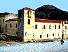
 The monastery Jagarolon is located 15
km east of Hania, near the village of
Koumares. It was built in 1612 by the monks
Laurentius and Jeremiah, members of the
Venetian orthodox family Jagarolon, after
which the monastery was named. The
beautiful bell-tower was built in 1864.
During the Revolution in 1821, the
place was burned down by the Turks, and
was renovated years later by the monks
Calliopios and Gregorios, from Akrotiri.
Today, the monastery includes a
library, a collection of icons and codes, and it
houses the Seminary of Crete.
The monastery Jagarolon is located 15
km east of Hania, near the village of
Koumares. It was built in 1612 by the monks
Laurentius and Jeremiah, members of the
Venetian orthodox family Jagarolon, after
which the monastery was named. The
beautiful bell-tower was built in 1864.
During the Revolution in 1821, the
place was burned down by the Turks, and
was renovated years later by the monks
Calliopios and Gregorios, from Akrotiri.
Today, the monastery includes a
library, a collection of icons and codes, and it
houses the Seminary of Crete.
 The monastery of Gouverneto is just 4
km north of the monastery of Agia Triada, 19
km east of Hania. It is dedicated to the
Presentation of Virgin Mary or, as it is known
widely, to the Lady of Angels. Is was during
the Venetian Rule, in 1548 and its altar was
decorated with venetian sculptures.
Although the monastery was
destroyed by the Turks during the Greek War
of Independence, in 1821, it was restored and
today it belongs to the monastery of Agia
Triada.
The monastery of Gouverneto is just 4
km north of the monastery of Agia Triada, 19
km east of Hania. It is dedicated to the
Presentation of Virgin Mary or, as it is known
widely, to the Lady of Angels. Is was during
the Venetian Rule, in 1548 and its altar was
decorated with venetian sculptures.
Although the monastery was
destroyed by the Turks during the Greek War
of Independence, in 1821, it was restored and
today it belongs to the monastery of Agia
Triada.
 The Naval Museum of Crete is
situated at Hania and housed in Fort Firkas.
Here are exhibited models of boats from the
ancient years until today, icons and heirlooms
from the glorious naval history of Crete.
The Naval Museum of Crete is
situated at Hania and housed in Fort Firkas.
Here are exhibited models of boats from the
ancient years until today, icons and heirlooms
from the glorious naval history of Crete.
 Omalos plateau is situated 39 km
south of Hania, on an altitude of 1,050 m.
surrounded by tall peaks. Its diameter is 4
km and on its centre stands the village of
Omalos. One can get to Omalos plateau from
the villages of Laki, Agia Roumeli and Agia
Irini. Its invincible location rendered the
plateau - during the Turkish Occupation - a
refuge for the persecuted fighters and has
served as a refuge to all fights of the Cretan
people, ever since.
In the past, the area had cultivation of
cereals and potatoes. Today, the locals occupy
themselves with stock-breeding and farming.
Omalos is also known for the hill of
Agios Pandeleimon, the house and grave of
fighter Hatzimichalis Giannaris - who helped
the Cretan fight for liberty in 1866, 1878,
1897 and 1912 - and the cave of Tzanis which
is the deepest in Greece (280 m. deep).
Omalos plateau is situated 39 km
south of Hania, on an altitude of 1,050 m.
surrounded by tall peaks. Its diameter is 4
km and on its centre stands the village of
Omalos. One can get to Omalos plateau from
the villages of Laki, Agia Roumeli and Agia
Irini. Its invincible location rendered the
plateau - during the Turkish Occupation - a
refuge for the persecuted fighters and has
served as a refuge to all fights of the Cretan
people, ever since.
In the past, the area had cultivation of
cereals and potatoes. Today, the locals occupy
themselves with stock-breeding and farming.
Omalos is also known for the hill of
Agios Pandeleimon, the house and grave of
fighter Hatzimichalis Giannaris - who helped
the Cretan fight for liberty in 1866, 1878,
1897 and 1912 - and the cave of Tzanis which
is the deepest in Greece (280 m. deep).
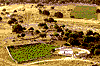 The green plateau of Askifou is
situated 50 km south-east of Hania. It is
surrounded by the peaks of Kastro (2,218 m.),
Tripoli (1,493 m.) and Agathes (1,511 m.), all
part of Lefka Ori. The fertile fields are
cultivated with potatoes, cereals, vineyards
and fruit-trees. Here, one can also visit the
village of Askifou.
According to tradition, "Askifou"
derives from the ancient Greek word "skifos"
(cup), a name suitable for the area. In August
1821, at the pass of Laggos, the Turkish army
of Sheriff Pasha was defeated by the Cretans.
The green plateau of Askifou is
situated 50 km south-east of Hania. It is
surrounded by the peaks of Kastro (2,218 m.),
Tripoli (1,493 m.) and Agathes (1,511 m.), all
part of Lefka Ori. The fertile fields are
cultivated with potatoes, cereals, vineyards
and fruit-trees. Here, one can also visit the
village of Askifou.
According to tradition, "Askifou"
derives from the ancient Greek word "skifos"
(cup), a name suitable for the area. In August
1821, at the pass of Laggos, the Turkish army
of Sheriff Pasha was defeated by the Cretans.
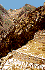
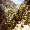
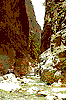 Samaria gorge is Crete's most visited
sight-seeing and one of the most beautiful
parts of Europe, as voted by the European
Council in 1980. It is the Continent's biggest
gorge, 18 km long, while its width varies
from 150 m. to 3 m., the most narrow
crossing being "Portes". According to
archaeologists, inside the gorge stood the
ancient city of Keno and Tara, where Tareos
Apollo was worshipped. During the Cretan
struggle for liberty, many persecuted fighters
sought refuge here.
One can enter the gorge following the
narrow path of Xiloskalo (1,227 m.), while
walking is 14 km and 6-8 hours long. To
travel through it, weather has to be good and
the gorge open, which only happens between
the months of May and October. Due to the
rich flora and fauna, the area was
pronounced "National Forest", in 1962. Here
lives the famous wild goat of Crete, called
"Kri-Kri", as well as rare kinds of birds, while
on the ground grow wildflowers and rare
kinds of herbs. There is running water
everywhere and sunlight comes and goes,
creating beautiful colourings.
In the gorge stand the deserted
villages of Agia Roumeli and Samaria, as well
as the picturesque chapel of Agios Nikolaos,
built in an area full of cypress-trees. The area
has been named after the church of Osia
Maria Egyptian or Sia Maria, found in the
village of Samaria and dating back to 1379.
For the protection of the National
Forest of Samaria, there are strict rules
prohibiting - among others - hunting, over-
night stay, camp-fire, littering, smoking or
picking flowers.
Samaria gorge is Crete's most visited
sight-seeing and one of the most beautiful
parts of Europe, as voted by the European
Council in 1980. It is the Continent's biggest
gorge, 18 km long, while its width varies
from 150 m. to 3 m., the most narrow
crossing being "Portes". According to
archaeologists, inside the gorge stood the
ancient city of Keno and Tara, where Tareos
Apollo was worshipped. During the Cretan
struggle for liberty, many persecuted fighters
sought refuge here.
One can enter the gorge following the
narrow path of Xiloskalo (1,227 m.), while
walking is 14 km and 6-8 hours long. To
travel through it, weather has to be good and
the gorge open, which only happens between
the months of May and October. Due to the
rich flora and fauna, the area was
pronounced "National Forest", in 1962. Here
lives the famous wild goat of Crete, called
"Kri-Kri", as well as rare kinds of birds, while
on the ground grow wildflowers and rare
kinds of herbs. There is running water
everywhere and sunlight comes and goes,
creating beautiful colourings.
In the gorge stand the deserted
villages of Agia Roumeli and Samaria, as well
as the picturesque chapel of Agios Nikolaos,
built in an area full of cypress-trees. The area
has been named after the church of Osia
Maria Egyptian or Sia Maria, found in the
village of Samaria and dating back to 1379.
For the protection of the National
Forest of Samaria, there are strict rules
prohibiting - among others - hunting, over-
night stay, camp-fire, littering, smoking or
picking flowers.
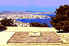 The graves of the Venizelos family are
situated on the hill of Prophetis Elias, 5 km
outside the city of Hania. There, in an area
with magnificent views of the city, Eleftherios
Venizelos was buried in 1936. In 1964, his
son, Sofocles, was also buried here. In 1897,
Cretan fighters raised the flag of the
revolution on this spot and demanded the
union of Crete to the rest of Greece. The
combination of the monument and the
beautiful view to Hania, fascinates the
visitors.
The graves of the Venizelos family are
situated on the hill of Prophetis Elias, 5 km
outside the city of Hania. There, in an area
with magnificent views of the city, Eleftherios
Venizelos was buried in 1936. In 1964, his
son, Sofocles, was also buried here. In 1897,
Cretan fighters raised the flag of the
revolution on this spot and demanded the
union of Crete to the rest of Greece. The
combination of the monument and the
beautiful view to Hania, fascinates the
visitors.


http://www.areianet.gr/infoxenios/
