Browse through our Interesting Nodes on the Cyprus Issue Read the Convention Relating to the Regime of the Straits (24 July 1923) Read the Convention Relating to the Regime of the Straits (24 July 1923)
HR-Net - Hellenic Resources Network Compact version
Today's Suggestion
Read The "Macedonian Question" (by Maria Nystazopoulou-Pelekidou)
HomeAbout HR-NetNewsWeb SitesDocumentsOnline HelpUsage InformationContact us
Friday, 29 March 2024
 
News
  Latest News (All)
     From Greece
     From Cyprus
     From Europe
     From Balkans
     From Turkey
     From USA
  Announcements
  World Press
  News Archives
Web Sites
  Hosted
  Mirrored
  Interesting Nodes
Documents
  Special Topics
  Treaties, Conventions
  Constitutions
  U.S. Agencies
  Cyprus Problem
  Other
Services
  Personal NewsPaper
  Greek Fonts
  Tools
  F.A.Q.
 

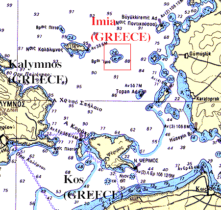
From the Hellenic Ministry of Foreign Affairs: Imia Rocks Maps


The first map is a color map of the area, showing where exactly the Imia rocks are.

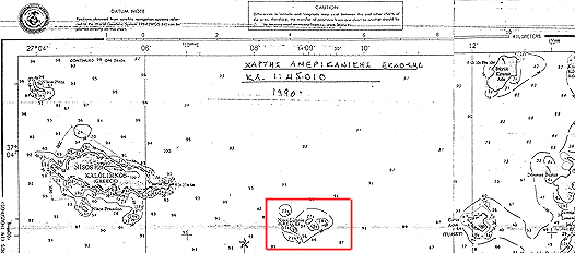
The second map is an american map of the territory dated 1990. Following this map, there is a blow up of Imia, presenting clearly that the publisher registers Imia rocks belonging to Greece.

Source: US map no 54418 prepared and published by the Defence Mapping Agency, Washington D.C. Nov 1990, 3rd edition


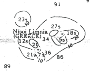
HR-Net Note: Please note that Imia and Limnia are two different names used for the same islets.


Documents and News on the Incident at Imia

Back to Top
Copyright © 1995-2023 HR-Net (Hellenic Resources Network). An HRI Project.
All Rights Reserved.